Neelam Valley

Neelum Valley is situated at the North & North-East ofMuzaffarabad Azad Kashmir, running parallel to Kaghan Valley. The two valleys are only separated by snow-covered peaks, some over 4000m above sea level. Excellent scenic beauty, panoramic views, towering hills on both sides of the noisy Neelum river, lush green forests, enchanting streams and attractive surroundings make the valley a dream come true.

Weather of Neelum Valley is very pleasant in summers and freezy in winters. Every years thousands of tourist rush to explore Neelum Valley. Some of Major Attractions for Tourists to Visit :-

Dhani Waterfall is about 30 Kilometers from Muzaffarabad, beautiful waterfall with 15 meters fall. From month of March ot June in every season water flow remains good but in July to onwards water level remain low.

 You May also Visit : Nanga Parbat

Chilhana/Titwal is border of Azad Kashmir and Indian occupied kashmir. In Chilhana, kashmiri colonies are located which are controlled by Indian administration. Attraction is watching out Indian side of Kashmir.

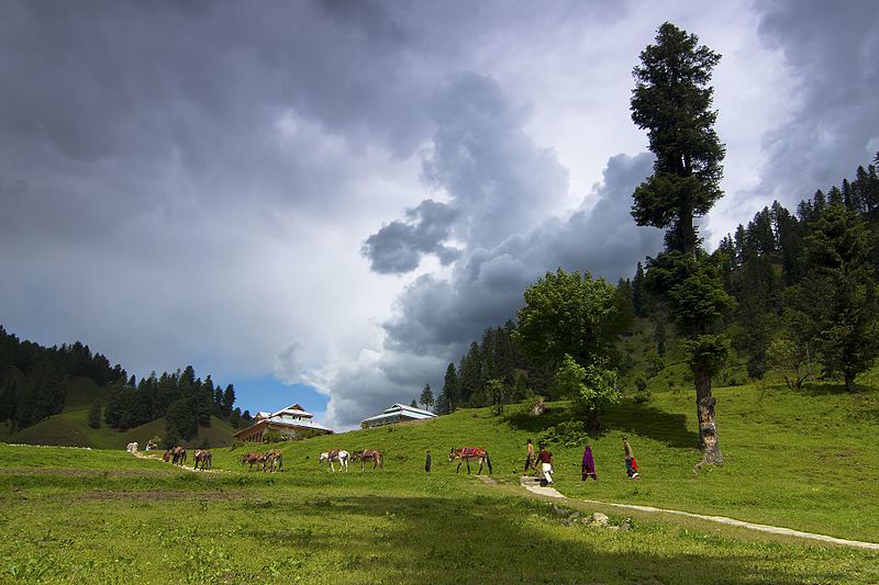
Kutton Jagran Valley is pearl valley with kutton waterfall, jagran stream, HEB resorts. Kutton is the first place where tourist plan to stay at.

Keran is located 93 kilometers away from Muzaffarabad and well known because of neelum river flowing peacefully. A tourist Motel by AJK Tourism is constructed to facilitate tourists.

Upper Neelum is 2 Kilometers away from Keran, it’s a most scenic place of Neelum Valley which shows the panoramic view of Valley. AJK TOURISM constructed small two bedrooms huts to facilitate tourists.

Sharda is tehsil headquater of Neelum District and about 43 kilometers from Keran Neelum Valley.

Kel is about 23 kilometers from sharda , it’s a jeep track and one the best location. Not enough facilities are available in Kel. Arrang Kel the Gold Village of Neelum Valley, if you are on visit to Neelum valley then must visit Arrang kel. 30 minutes walking trek from kel.

Life is simple here. And magnificent. It pleases the heart to see the smiles and experience the cordiality of people who have lived here.


You May also Visit : Naran

Nanga Parbat

Nanga Parbat, locally known as Diamer is the ninth highest mountain in the world at 8,126 metres (26,660 ft) above sea level. Located in the Diamer District of Pakistan’s Gilgit Baltistan region, Nanga Parbat is the western anchor of the Himalayas.
The name Nanga Parbat is derived from the Sanskrit words nagna and parvata which together mean “Naked Mountain”. The mountain is locally known by its Tibetan name Diamer or Deo Mir, meaning “Huge Mountain”.

Nanga Parbat was first climbed, via the Rakhiot Flank , on July 3, 1953 by Austrian climber Hermann Buhl, a member of a German-Austrian team.In 1984 French climber Lilliane Barrard became the first woman to summit Nanga Parbat. After 31 people died attempting to climb Nanga Parbat before it’s 1953 first ascent, it was nicknamed the “Killer Mountain.”

Ratti Gali Lake

Ratti Gali Lake is a beautiful lake of Neelum Valley in Azad Kashmir.It is a distance of around 100 km from Muzaffarabad.This lake is situated above 12,130 Ft from sea level..The rodes remain closed through out the year due to heavy snowfall.The lake is reachable only for 4×4 vehicle during july-october each year.It is a beautiful site which attracts a tourist.

Rawalakot

Location:

Rawalakot is located at Latitude 33°51’32.18″N, Longitude 73° 45’34.93″E and an Elevation of 5374 feet. Rawalakot is approximately 76 kilometres (47 mi) from Kahuta and about 120 km (75 mi) from the city of Rawalpindi, Pakistan.. It is linked with Rawalpindi and Islamabad via Goyain Nala and Tain roads. Via Kotli Satiyan and Kahuta. It is also linked with Rawalpindi via Sudhnuti.

Culture:

Rawalakot city and its surroundings are very peaceful and beautiful. Most people living here are Sudhans. They moved to the Poonch district of Kashmir region some centuries ago.

Tourism:

Banjosa and Toli pir two popular tourism destination in this area. Lodges, government-owned and private guest houses, and hotels are available in different parts of Rawalakot. Attractions include: mountain-based adventure tourism, rock climbing, mountaineering, trekking, summer camping and hiking, water-based adventure tourism, and paragliding.
A Temple is located about two kilometer away from city Rawalakot near the upper block Faculty of Veterinary & Animal Sciences. The University of Poonch, Standing near the temple presents a charming sight of Rawalakot city also the beautiful view of The University of Poonch

Neelam Valley

Location:

The Neelam River was known before Partition as Kishan Ganga and was subsequently renamed after the village of Neelam. It flows down from the Gurez Valley in Indian Jammu and Kashmir and roughly follows first a western and then a south-western course until it joins the Jhelum River at Muzaffarabad. The valley is a thickly wooded[citation needed] region with an elevation ranging between 4,000 feet (1,200 m) and 7,500 feet (2,300 m), the mountain peaks on either side reaching 17,000 feet (5,200 m).Neelum Valley is 144 kilometres (89 mi) long.

Administration:

Neelam District was part of Muzaffarabad District until 2005. It is made up of two tehsils: Athmuqam, which contains the district headquarters, and Sharda. Neelam District is the largest district of Azad Kashmir by area. The valley extends for approximately 200 kilometers along the Neelam River. This is a generally poor region, reliant on subsistence agriculture and handicrafts, with tourism growing in importance in recent years.
According to the Alif Ailaan Pakistan District Education Rankings 2015, Neelam is ranked 33 out of 148 districts in terms of education. For facilities and infrastructure, the district is ranked 136 out of 148.

Sub-Valleys in the Neelam Valley:

Neelum Valley has three sub-valleys within itself.[citation needed] These are
Leswa Valley
Jagran Valley
Babboon Valley
Shounter Valley
Salkhala Valley